Preliminary evidence review • Updated October 14, 2026, 8:08 p.m. CDT • Prepared by ChatGPT for Doug Liles from the cited records.
Raven in 30 seconds
THE PROPOSAL
22 homes proposed; later-phase count needs clarification
The narrative describes 22 Phase I homes and 24 future villas; the engineering master-plan table lists 22 future multifamily units. Neither establishes a final approval. See the accuracy notes below.
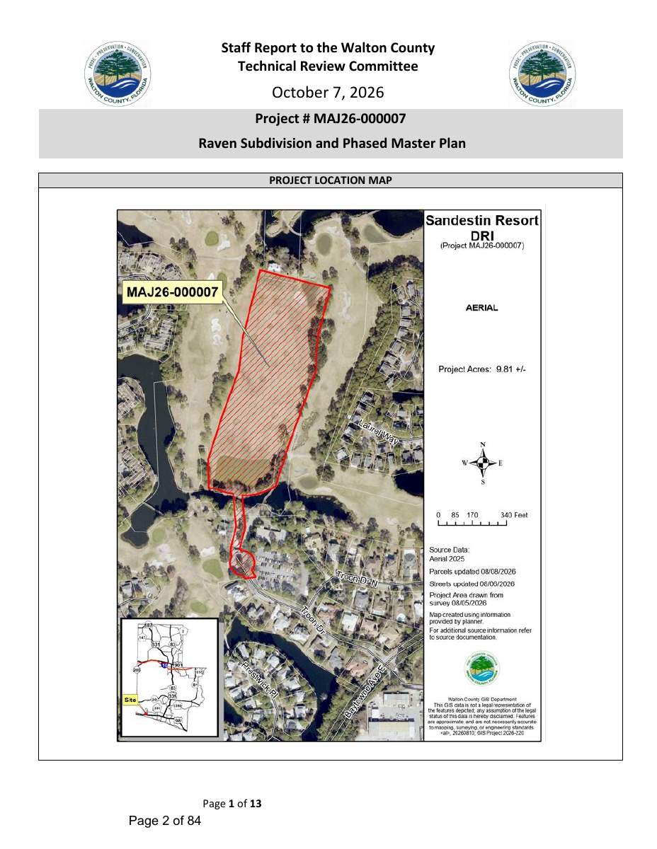
The county's project-location map outlines the proposed area in red. Existing homes, golf facilities and lakes surround it; Troon Drive provides the location reference near the southern entrance.
Source: Walton County, October 7, 2026 Raven staff report, page 1; complete packet page 2. Unaltered page rendered as an image for easier viewing. The county labels the map approximate; it is not a boundary survey.
Drainage connection still to verify: this aerial shows proximity, not flow direction. We have not drawn a discharge route to the bay or a flood-impact area. Those require the approved plans, outfall mapping and technical review.
Compare the documents
These are documented differences to resolve. A later letter may revise an earlier proposal; the public record should identify the controlling version and reconcile its calculations.
1. Which parcels supply the 22 residential units?
MARCH 20 NARRATIVE
Parcel 209 → 22 units
Describes a transfer from Parcel 209 to Parcel 428, leaving 2 units on Parcel 209.
Why it matters: the sources and remaining balances must support the requested allocation. The different accounts do not by themselves establish duplicate use of units.
Why it matters: these figures use different counting assumptions. The community needs to know what qualifies as protected open space and whether the DRI-wide requirement remains satisfied.
What would resolve this?
A mapped open-space schedule showing existing acreage, conversion acreage, qualifying retained areas and the resulting DRI-wide total, with the controlling definition and approval cited. County open-space reconciliation comment · packet page 6.
3. Which land-use standards control?
APPLICANT NARRATIVE
Mixed Use / Coastal Center
The narrative identifies these as the future land use and zoning.
Why it matters: reviewers should identify the governing designations and any applicable DRI standards. This may be a clerical error; the difference alone does not establish that a rezoning is needed.
What would resolve this?
A corrected staff table and confirmation against the adopted maps and controlling DRI approvals, identifying any effect on the compliance analysis.
Your next useful step
Ask for a reconciled record and verified drainage analysis. Use the editable commissioner letter, share this page, or send dated local flooding evidence for review.
Next Raven hearing: not confirmed in this review. Check the official agenda and submission instructions before relying on a meeting date or comment deadline. Official county agendas.
How the record developed
February 11, 2026 · Meeting recorded The staff report lists a pre-application meeting; underlying notes and concept plans remain to be obtained. Source.
March 20, 2026 · Applicant narrative Describes the phases, Parcel 209 transfer and 6.3-acre open-space reduction. Source.
April 21, 2026 · Allocation letter Proposes different donor parcels and a maximum 9.52-acre open-space reduction. Source.
October 7, 2026 · Published TRC packet Staff identifies unresolved review items and recommends conditional approval. This does not establish the meeting's outcome or a final approval. Source.
What is proposed
The March 20 narrative describes replacing the driving range and practice facilities with 22 detached homes and an interior road, with 24 villas contemplated later. The engineering master-plan table instead lists 22 future multifamily units. The final later-phase count and approval scope need clarification. This proposal does not establish permanent closure of the entire golf course.
Which parcels supply the development rights, and does the final ledger reconcile?
Which open-space reduction applies—6.3 or 9.52 acres—and what remains protected?
Which land-use labels and standards control the review?
What would be approved now, and what remains conceptual?
Where does runoff discharge, and what do the models show for neighboring properties and receiving waters?
The county staff report identifies conflicting figures and unresolved review items. These warrant written answers; discrepancies alone do not prove wrongdoing.
Page references below use the complete packet's PDF page numbers. Page jumps depend on your PDF viewer. These are county-hosted source records; our summaries are preliminary analysis.
CONFIRMED DATE · UNDERLYING NOTES NOT YET LOCATED
February 11, 2026: pre-application meeting
The county staff report records a meeting with the applicant on this date. That is a precise starting point for tracing the original proposal.
Still needed: the meeting request, separate tracking number, initial concept plans, staff notes or written comments, and follow-up correspondence. These are not listed among the packet's attachments; the underlying pre-application file has not been recovered in this review.
Compare the initial unit count, phases, drainage footprint and requested studies against the current application. Search by Parcel 428, all four county parcel IDs, ECAE and the owners, as well as Raven.
DOCUMENT FOUND · ENTITLEMENT HISTORY NEEDS RECONCILIATION
Where the 22 development rights would come from
An April 21, 2026 ECAE letter proposes 16 units from Parcel 224A (Osprey Point) and 6 from Parcel 320.1 (Grand, Lasata, Bahia and Elation).
Read the allocation letter and follow its references
The letter cites Exhibit E of the Sandestin 2024 Biennial Report as the approved pre-transfer allocation. The complete report, approval and subsequent allocation changes still need to be obtained and checked. Its stated post-transfer balances are 0 remaining units on 224A, 80 on 320.1 and 22 on 428.
The staff report flags a different donor, Parcel 209, in the March 20 narrative. Compare the signed letters, controlling Exhibit E, approvals and dated revisions to establish which allocation governs and whether the same units remain available.
Different kinds of credits: residential development rights are separate from wetland mitigation-bank credits. Each has its own ledger and approval trail.
SOURCE MATERIAL AVAILABLE · TECHNICAL REVIEW OUTSTANDING
What the plans and environmental assessment cover
The packet includes a boundary/topographic survey, engineering construction plans, environmental assessment, traffic drawdown statement and existing-conditions materials.
The staff report describes an assessment of approximately 12.5 acres with no jurisdictional wetlands identified. Match its surveyed boundary to the proposed construction, drainage works and future-phase footprint. A current no-wetlands finding does not establish whether older conservation restrictions or mitigation obligations apply.
For drainage, obtain the native model, calculations, design storm assumptions, groundwater and receiving-water levels, outfall details, and maintenance obligations. Compare approved existing conditions with proposed conditions and impacts on neighboring properties. The public packet is not a substitute for independent verification of the model.
Trace the permits to the land
Not yet verified: an environmental authorization covering this construction footprint. Searches by name, owner and section found other Sandestin or nearby records, but no approved boundary map has yet connected one to Raven. An unsuccessful search does not establish that authorization is absent.
Project identifiers for cross-searching
County project: MAJ26-000007 · Sandestin DRI Parcel 428 · ECA project 25-051 · Troon Drive, Miramar Beach. Owners named in the county record: Sandestin Investments LLC, Sandestin Holdings LLC and Sandestin Owners Association Inc. Applicant: Dean A. F. Burgis, ECAE LLC.
26-2S-21-42000-001-0000
26-2S-21-42000-001-0001
26-2S-21-42000-001-00A0
26-2S-21-42000-001-00B0
Section 26, Township 2 South, Range 21 West. DRI parcel numbers and county tax parcel IDs are different identifiers. A section-level match or matching owner alone does not demonstrate permit coverage.
State permits, older master permits and modifications
Check for an existing master authorization, modifications, pending applications, exemptions and any qualifying DEP self-certification. Match approved permit boundaries, drainage basins and outfalls to the surveyed construction footprint.
DEP's published ledgers are another route to an impact-permit number. Cross-search project and predecessor names, owners and permit numbers; then trace any debit to the impact permit and approved map. No transaction has been verified as covering Raven in this review.
Check the ledger date, bank service area, credit type, quantity, debit approval and any return or correction. DEP handles mitigation-bank permitting within NWFWMD boundaries. A bank credit addresses its specified mitigation obligation; flood protection and pollutant transport require separate evidence.
Conservation easements, plats and original development approvals
Trace the original Sandestin DRI development order and amendments, recorded conservation easements and plats, and any Army Corps permits identified by those records. Compare legal descriptions and approved maps with the Raven footprint; a Sandestin-wide name match is only a lead. No conservation restriction has yet been verified as covering this construction footprint.
Available: October 7 county staff report and 84-page packet, including the April 21 allocation letter.
Requested from county planning: the complete project file, drainage models, revisions, current status and official comment instructions. A response has not been verified in this review.
Requested from NWFWMD: parcel-specific authorizations, older master permits or modifications, exemptions or certifications, and approved boundary maps. A response has not been verified in this review.
Next targeted records: February 11 pre-application file and the complete 2024 Biennial Report with controlling Exhibit E, approval and later amendments. These specific follow-up requests have not been sent as part of this update.
The October 21 TRC meeting appears on the county calendar. Raven's inclusion and the applicable comment deadline remain unconfirmed; do not rely on that date as a confirmed Raven hearing.
The Good Samaritan Institute’s SaveOurBay project describes one pooled sample of livers from 13 catfish collected at Ditch #10 in Santa Rosa Beach. The linked Pace report documents PFAS detections in the sample identified as catfish livers. This is an existing watershed concern—not a finding that Raven caused contamination. It does not measure edible fillets or establish a hydrologic connection to this project.
Our request: verify the drainage pathway, assess potential pollutant mobilization, and establish appropriate baseline testing before disturbance where supported by the evidence.
Sampling location and pooling details are attributed to the project’s account; they have not been independently reconstructed here. One pooled sample cannot establish how common contamination is across the bay or how much each fish contributed.
Share the proposal, the unanswered questions and the call for independent flood and water-quality review.
Instagram and TikTok: Copy the caption below for your post, Story or video. Add the published page link wherever your account supports links. Direct posting is not provided by this page.
Share this evidence review with your neighbors. Posting availability varies by device and app.
Write your commissioners
Personalize the letter, choose a recipient and review the draft in your email app before sending. Contacting commissioners does not automatically place comments into the project record or preserve any review rights. Ask county planning for the proper submission channel.
Addresses checked against the official county directory October 14, 2026. Messages to public officials may become public records; omit sensitive personal information.Official commissioner directory
Share evidence and local experience
Document flooding with dates, locations, rainfall context and photographs when available. Send source documents or corrections to Protect30A for review. Submissions are not automatically published or submitted to the county.
Review status · October 14, 2026, 8:08 p.m. CDT: this is a public advocacy summary of a preliminary documentary review. It is not a peer-reviewed study, independent engineering certification or finding that the project causes flooding or pollution. “Protect the Bay. Prevent More Flooding.” states the campaign’s goal, not an established project impact.
What the record also says in the project’s favor
The staff report recommends approval with conditions. Its floodplain reviewer reports no outstanding floodplain issues and describes approximately 6,194 cubic feet of fill with 138,724 cubic feet of additional storage. The environmental summary reports no jurisdictional wetlands and no observed evidence of hazardous materials or contamination. These findings belong in a balanced account.
Additional differences found during this source audit
Later-phase unit count: the narrative describes 24 villas; the engineering master-plan table lists 22 multifamily units and 44 units overall (22 + 22). Identify the controlling revision and approval scope. Narrative · page 15 / Master-plan table · page 26.
Assessment chronology: the environmental assessment states a field survey on December 15, 2026, later than the October 7 packet. Staff instead references an assessment dated January 19, 2026. Obtain the corrected date, original report and field records; a date error does not establish that the survey never occurred. Assessment · page 53 / Staff reference · page 6.
Legal-location label: the engineering cover says Section 23, while the narrative and internal plan sheet identify Section 26, Township 2 South, Range 21 West. Confirm the correct legal description and whether the cover requires correction. Cover · page 24 / Narrative · page 15 / Plan · page 26.
Permit-route eligibility: staff mentions an ERP or qualifying “10-2” self-certification, but the engineering table lists an 11.09-acre master-plan site and 6.11 acres of Phase I impervious surface. Those figures need agency reconciliation with the stated less-than-10-acre and less-than-2-acre thresholds. No eligibility, exemption or violation is established here. Staff condition · page 4 / Plan table · page 26.
These observations were checked visually on the source pages. Different dates, scopes or plan revisions may explain some differences; an agency or applicant response has not been verified in this review.
How this review was conducted—and how to reproduce it
We compared the narrative, staff report, allocation letter and selected engineering and environmental pages within the county-published 84-page packet. Text extraction was checked against rendered pages for the newly reported date, location and plan-table differences. Links identify complete-packet PDF pages. The source remains authoritative; the summaries and suggested actions are AI-assisted interpretation.
Permit searches were exploratory, not an exhaustive historical title or permit search. No native drainage model was rerun, no field survey or sampling was performed for this review, and no developer or agency response to these specific audit questions has been verified. Our absence of a record is not proof the record does not exist. Favorable findings and unresolved questions are reported together.
Applicant narrative, March 20; county staff report and TRC agenda, October 7; Pace laboratory report, May 21, 2024; official commissioner directory, checked October 14, 2026.
October 14, 2026, 8:08 p.m. CDT: Audited source pages and corrected stale statements in the detailed review. Added favorable findings, later-phase count and chronology differences, legal-location and permit-route questions, sampling-provenance limits and a reproducible source register. The map, comparisons, timeline and source layers remain available. Records correspondence now uses digitalcommons@icloud.com. Engineering-model verification, permit-boundary matching and the next project hearing remain unresolved. Updated manually.